Industry Insights
Helping Drones Chart a Better Path
Earthquakes can cause massive destruction. Their aftermaths can also destabilize structures, leading to further safety risks for first responders. Robots, especially unmanned aerial vehicles (UAVs), can enter these unstable environments, map the scene, and look for survivors much faster -- and more safely -- than humans . To do this, UAVs requires trajectory planners (software) that determine how they get from point A to point B during a rescue.
However, the systems need to quickly adjust their trajectories when looking for earthquake survivors to avoid obstacles. This is challenging for autonomous drones, but researchers from MIT and the University of Pennsylvania have developed a new open-source trajectory-planning system called MIGHTY that helps UAVs to avoid obstacles in milliseconds while maintaining a smooth flight path―which minimizes the travel time for the UAVs, and time is critical in rescue operations.
MIGHTY
The MIGHTY System is a mathematical formula, called a Hermite spline, that optimizes the time and flight path in a single step. This forms a smooth travel trajectory that can be precisely controlled. Bringing together the temporal and spatial components is known to provide better trajectory results but typically requires more computational power—which can make the computing process much slower.
Existing methods usually estimate how long it will take the UAV to travel from point A to point B, and using this fixed time estimation, the planner of the UAV identifies the best path to reach the destination. However, in these approaches, the UAV may be forced to go out of its way to avoid obstacles. To meet the time requirements of the fixed time estimation, UAVs have to speed up, making it difficult to avoid some hazards.
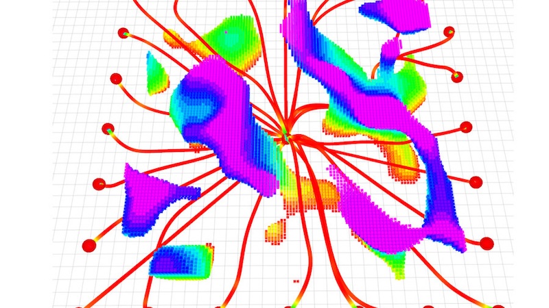
The MIGHTY method overcomes these issues by combining the temporal and spatial components —including the path geometry, timing, velocity, and acceleration. It doesn’t generate a trajectory for the UAV from scratch each time it makes a new trajectory, it instead refines the trajectory through iterative optimization. This iterative optimization process utilizes a map of the scene created by LiDAR sensors on the UAV, making it much easier and quicker to generate new trajectories, rather than generating them from nothing.
NEW ONLINE TRAINING COURSE
Designing Industrial AI Agents
Gain the skills to orchestrate advanced AI agents that learn, adapt, and collaborate like experts in real-world automation environments
This saves on computational power that allows both components to be combined without trade-offs. It also gives the UAVs the ability to compute faster and dynamically move in cluttered environments, and no proprietary software is needed as it works on an open-source system.
The system is efficient enough to facilitate real-time flight trajectory changes and obstacle avoidance when the UAV is moving, using only the onboard computer and sensors of the UAV (no new hardware needed). The open-source nature of the system means that anyone can use it around the world without financial barriers. There are some other systems out there that can also rapidly generate smooth trajectories, but they cost hundreds of thousands of dollars that limits who can use them.
Effectiveness of the MIGHTY System
Simulated experiments have shown that the MIGHTY only needs 90% of the computation time required by other methods and the UAVs safely reach the destination 15% faster. When the MIGHTY system was tested on real UAVs, the UAVs reached speeds of 6.7 m/s while avoiding every obstacle in its path.
Future directions for the MIGHTY system include enhancing its capabilities so that it can be used to control multiple UAVs at the same time, which will allow more complex environments to be explored, and will use user feedback (as its open source) to improve it. Alongside search-and-rescue missions, the MIGHTY system could also find use in last-mile delivery applications within urban spaces where UAVs regularly navigate cluttered environments and avoid buildings, wires, and people, as well as being used to inspect complex industrial systems such as wind turbines.
Association for Advancing Automation
Discover how Association for Advancing Automation can support your automation journey with their complete range of solutions and expertise.
Visit Company Website


